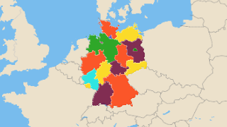
List and Map of German States
Interactive map of the states of Germany. Population and area information of the states.
- Germany has 16 States
- North Rhine-Westphalia is the largest of the states by population
- Berlin, Hamburg ve Bremen are single city states. They do not have separation between state government and local government.
List of German States
| Flag | Coat of Arms | Bundesland | Population | Area (km2) |
|---|---|---|---|---|
 |
 |
Nordrhein-Westfalen | 17,837,000 | 34,147.993 |
 |
 |
Bayern | 12,542,000 | 70,674.14 |
 |
 |
Baden-Württemberg | 10,755,000 | 36,049.685 |
 |
 |
Niedersachsen | 7,914,000 | 47,705.965 |
 |
 |
Hessen | 6,066,000 | 21,136.817 |
 |
 |
Sachsen | 4,143,000 | 18,462.888 |
 |
 |
Rheinland-Pfalz | 4,052,803 | 19,875.872 |
 |
 |
Berlin | 3,440,441 | 891.362 |
 |
 |
Schleswig-Holstein | 2,833,000 | 15,732.426 |
 |
 |
Brandenburg | 2,500,000 | 29,685.332 |
 |
 |
Sachsen-Anhalt | 2,331,000 | 20,574.636 |
 |
 |
Thüringen | 2,231,000 | 16,213.331 |
 |
 |
Hamburg | 1,788,000 | 752.678 |
 |
 |
Mecklenburg-Vorpommern | 1,639,000 | 23,120.138 |
 |
 |
Saarland | 1,018,000 | 2,572.73 |
 |
 |
Bremen | 661,000 | 387.577 |
